
Cape Caution is the most significant “gate” along the Inside Passage. It’s one of just two places a vessel transiting between Washington State and Southeast Alaska must venture out of protected water and into the exposed Pacific Ocean. Many lifelong Pacific Northwest cruisers first experience ocean swells on the trip around Cape Caution.
Compared to the gates further south, like the Strait of Georgia, rounding Cape Caution is more challenging. You’re exposed to local wind waves and ocean swell—typically for at least twice as long as a voyage across the Strait of Georgia. Shelter and help are further away. Current must be accounted for, both to speed things up and avoid swell-against-current conditions. Fog is common.
Don’t be discouraged, though. Many summer days bring reasonable conditions. Some days are downright calm, with just a lazy ocean swell. We hope the following information will help you understand how to safely and comfortably navigate around Cape Caution!
Weather resources
Environment Canada is the best place to start. Most of the trip around Cape Caution is in the Central Coast From McInnes Island to Pine Island zone, but other forecast zones should also be considered. We look at the forecast for Queen Charlotte Sound- eastern half (to the west of our route) and Queen Charlotte Strait (at the south end of our route).
For a number of years now, we’ve used Windy.com (both the web interface and their app) and have been impressed with its accuracy and presentation. The Environment Canada forecasts cover large areas over big chunks of time. Windy allows users to look at forecast data in more granular ways, showing hourly forecasts for as wide or as narrow an area as the user wants. Often, an early morning lull will be apparent on Windy but not on the Environment Canada forecasts.
Click here to read “Getting the most out of Windy.com”
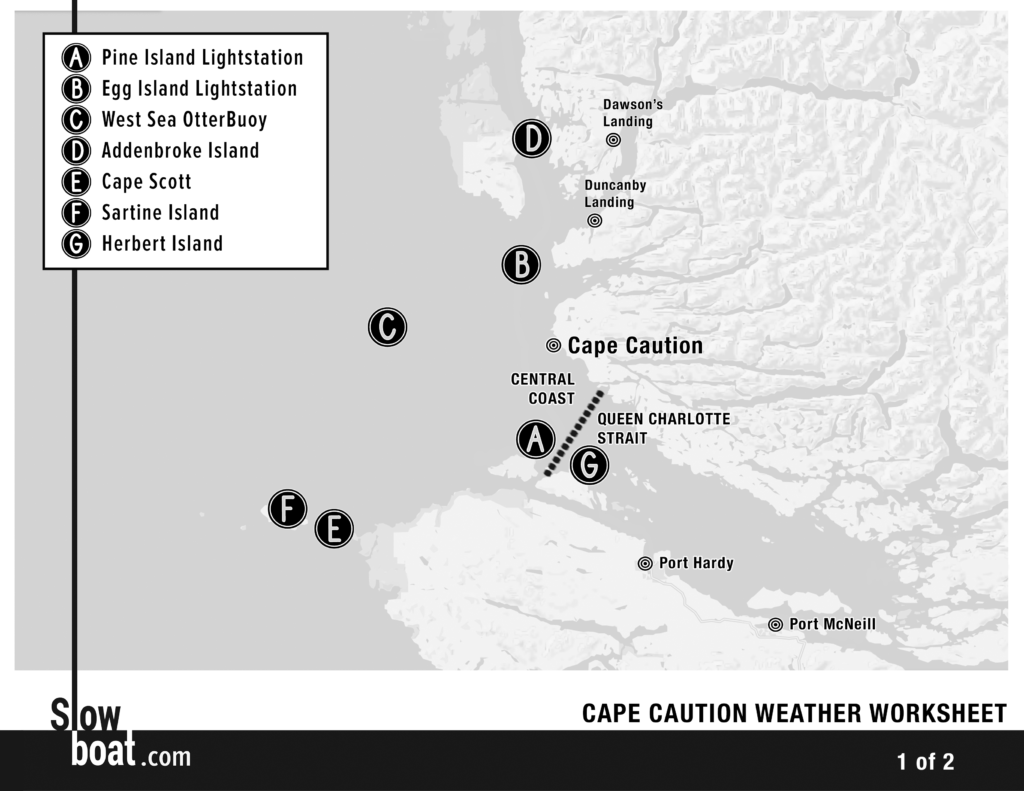
Even the best weather forecasts, though, are mere theory. Before embarking on a trip around Cape Caution, we like to see what the actual conditions are. We do this primarily using three weather reporting sites: Pine Island light station, Egg Island light station, and West Sea Otter weather buoy.
Click here to read “Building a Weather Picture”
Weather worksheet
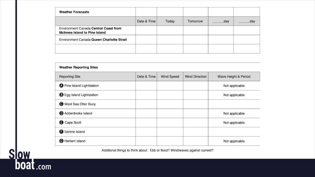
We use these worksheets to help plan our Cape Caution roundings (PDFs here: Cape Caution Weather Worksheet Page 1 Cape Caution Weather Worksheet Page 2). Links for each of the weather forecasts and reporting sites are located below.
We like printing these out and filling them in to help us paint a “picture” of the weather all along our route. Try it a few days ahead of time, too, and you’ll start to understand how closely forecasts tend to match conditions and when (or if) afternoon winds typically build.
Weather links:
Environment Canada Queen Charlotte Strait weather
Environment Canada Central Coast marine weather
C West Sea Otter weather buoy
B Egg Island lightstation weather
A Pine Island lightstation weather
D Addenbroke Island lightstation weather
E Cape Scott lightstation weather (scroll down)
F Sartine Island weather station
G Herbert Island weather station
Our limits
We like the West Sea Otter buoy to show 1.5 meters or less, with a wave period in seconds longer than the wave height in feet. The larger the multiple between wave period and wave height, the more comfortable the ride will be. Additionally, we like to see two-foot-chop or less at Egg Island and Pine Island. Three-foot-moderate isn’t much fun, and four-foot-moderate is a pretty good sign to wait for a better day. We prefer transiting during a flood, since the ebb can create bumpier conditions as water rushes out of inlets and collides with incoming swell.
Have a plan B. And C.
Look ahead
Don’t lock yourself into too rigid a schedule. Try to stay flexible enough to speed up or slow down your trip well in advance of weather systems you are seeking to avoid. Here’s an example…
We’re in Echo Bay. Tomorrow looks really good for Cape Caution, but the extended forecast is lousy. Tomorrow we’re supposed to go to Port McNeill to resupply. We can get there, but then we’re stuck for three or four or more days. More fun options: slow down and enjoy the Broughtons until the wind blows itself out, or speed up and go directly from Echo Bay to Fury Cove. We chose to speed up, and had a wonderful trip around Cape Caution and enjoyed a more relaxed pace for a few days since we were then ahead of schedule.